Результаты поиска
Перейти к навигации
Перейти к поиску
Совпадения в названиях страниц
Файл:The-effect-of-the-coriolis-force-the-rocket-example-atmosphere-earth-sciences u-l-q135jew0.jpg (550 × 550 (38 Кб)) - 13:06, 28 апреля 2021
Файл:Conceptual-model-for-the-evolution-of-the-debris-flow-channel-in-three-stages-at-the.png (850 × 936 (1,17 Мб)) - 15:45, 21 апреля 2022
Файл:Cross-section-showing-the-presence-of-an-alluvial-deposit-below-the-sliding-mass-in-the.png (624 × 347 (183 Кб)) - 13:23, 7 декабря 2021
Файл:Particle size distribution (PSD) of the sediments.png ...ffected by gravity erosion: a field study on steep loess slopes // Journal of Soils and Sediments. – 2020. – Т. 20. – № 3. https://doi.org/10.10(850 × 336 (279 Кб)) - 06:55, 14 апреля 2024
Файл:Schematic-of-the-modified-hydrology-scheme-adapted-from-Asare-et-al-48-Precipitation.png (850 × 317 (70 Кб)) - 14:23, 28 апреля 2021
Файл:Schematic diagram of the physically-based distributed sediment runoff model within grid-cell scale. .png Schematic diagram of the physically-based distributed sediment runoff model within grid-cell scale.(961 × 370 (352 Кб)) - 01:37, 30 апреля 2021


Совпадения в текстах страниц
Файл:Braided channel as example - Brahmaputra River.jpg Landsat photograph (courtesy of C. S. Bristow) of the Brahmaputra River immediately(640 × 448 (229 Кб)) - 12:04, 11 мая 2021
Файл:Hydrological cycle.png ...e. The numbers represent estimates on the total amount of water (thousands of km3) in each process per annum. E = evaporation; P = precipitation; QG = su(708 × 479 (60 Кб)) - 08:56, 21 декабря 2021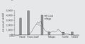
Файл:Фвуыфцв.jpg Rainfall distribution across the Southern Alps of New Zealand (South Island). Shaded areas on(1352 × 712 (84 Кб)) - 02:47, 21 декабря 2021
Файл:Inundation vs submergence vs flooding.png Discussion on the differences of the terms flooding, inundation and submergence(2133 × 1600 (1,74 Мб)) - 22:15, 7 декабря 2021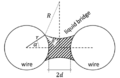
Файл:Capillary forces.png Schematic of the cross-section of two parallel, cilindrical wires of radius r, connected by a liquid bridge.(456 × 296 (41 Кб)) - 05:37, 7 мая 2021
Файл:Ultimate sink.jpg Deep seafloor plastics as the source and sink of organic pollutants in the northern South China Sea(1274 × 531 (200 Кб)) - 09:44, 27 апреля 2021
Файл:Freezing front.png ...ng front where water freezes to form segregated ice. Water moves upward to the frozen fringe within which hydraulic conductivity drops drastically as temp(782 × 773 (66 Кб)) - 00:47, 6 мая 2022- ...0.jpg|мини|272x272пкс|Top plunge point location and velocity as a function of Froude number]] The plunge point is the main mixing point between river and epilimnetic reservoir water. <ref>https1 Кб (96 слов) - 14:34, 28 апреля 2021
- ...vided by either the rate of addition of water to the reservoir or the rate of loss from it [2]. ...are useful tools to reveal the relationship between the residence time and the water quality [3].2 Кб (107 слов) - 03:56, 17 декабря 2023
- ...highest level of the horizon (NPU) and the level of maximum development of the reservoir (UMO). ...ign.<ref>Wisser D. et al. Beyond peak reservoir storage? A global estimate of declining water storage capacity in large reservoirs // Water Resour. Res.2 Кб (110 слов) - 17:19, 20 декабря 2023
- [[Файл:The-effect-of-the-coriolis-force-the-rocket-example-atmosphere-earth-sciences u-l-q135jew0.jpg|мини|Coriolis ...frame with clockwise rotation, the force acts to the left of the motion of the object. <ref>https://www.britannica.com/science/Coriolis-force</ref>2 Кб (181 слово) - 12:08, 1 августа 2021
- ...watercourse <ref>Max Derruau , ''The forms of terrestrial relief. Notions of geomorphology'' , Paris, Armand Colin. 1969. – Vol. 8. – p. 42-52.</ref ...ion (the profile) of a watercourse. <ref>A. Oye Cukwurah, ''The Settlement of Boundary Disputes in International Law'', Manchester University Press, 19672 Кб (95 слов) - 02:01, 15 апреля 2022
- ...<ref name=":0">[http://mgmtmo.ru/edumat/wmo/385.pdf International Glossary of Hydrology]</ref> Quantity of snow, or any other form of water in the solid state, which is added to a glacier, floating ice or a snow cover. <re2 Кб (117 слов) - 08:24, 22 апреля 2023
- ...rd streamflow uniquely describes the discharge in a surface stream course. The term "streamflow" is more general than runoff, as streamflow may be applied583 байт (68 слов) - 11:57, 5 октября 2021
- An escape of oil into the sea or other body of water.<ref>Cambridge Dictionaries Online // Choice Rev. Online. 2007. Vol. ...ponse methods.<ref>Cakir E., Sevgili C., Fiskin R. An analysis of severity of oil spill caused by vessel accidents // Transp. Res. Part D Transp. Environ1 Кб (74 слова) - 23:55, 14 апреля 2022
- ...nd around the edges of islands.<ref name=":0">Hicks F. The wonderful world of river ice. CreateSpace Independent Publishing Platform. 2013.</ref> ...sest to the bank will freeze right to the river bottom. Further out, where the flow is moving faster, border ice can be very thin and fragile.<ref name=":2 Кб (109 слов) - 22:48, 11 сентября 2021
Файл:Particle size distribution (PSD) of the sediments.png ...ffected by gravity erosion: a field study on steep loess slopes // Journal of Soils and Sediments. – 2020. – Т. 20. – № 3. https://doi.org/10.10(850 × 336 (279 Кб)) - 06:55, 14 апреля 2024- ...ods that have been observed in the past can be complied by the analysis of the observed discharge data and runoff hydrographs.<ref>Peak-Flow Frequency Est ...on limb based on the measurable characteristics.<ref>Davie T. Fundamentals of Hydrology, Second Edition. – Oxon: Routledge, 2002.</ref>2 Кб (133 слова) - 02:56, 9 сентября 2021
- ...eatments to Filtrate Water.jpg|альт=Процесс водоподготовки|мини|300x300пкс|The water treatment process<ref>https://homespe.com/how-to-improve-water-qualit The act or process of making water more [[Potable water|potable]] or useful, as by purifying, cla2 Кб (165 слов) - 07:48, 25 апреля 2023
- ...ly expressed in mass or volume per unit of time<ref>International Glossary of Hydrology, World Meteorological Organization, 2012, 471 p.</ref>. ...ter concentrations in the Danube River from Landsat ETM data // Science of The Total Environment. V. 37 (1-3). 2008. P. 283-243. </ref>.2 Кб (132 слова) - 23:54, 8 сентября 2021


_of_the_sediments.png)
Просмотреть (предыдущие 20 | следующие 20) (20 | 50 | 100 | 250 | 500)