Результаты поиска
Перейти к навигации
Перейти к поиску
Совпадения в названиях страниц
Файл:The-effect-of-the-coriolis-force-the-rocket-example-atmosphere-earth-sciences u-l-q135jew0.jpg (550 × 550 (38 Кб)) - 13:06, 28 апреля 2021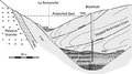
Файл:Cross-section-showing-the-presence-of-an-alluvial-deposit-below-the-sliding-mass-in-the.png (624 × 347 (183 Кб)) - 13:23, 7 декабря 2021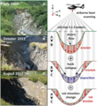
Файл:Conceptual-model-for-the-evolution-of-the-debris-flow-channel-in-three-stages-at-the.png (850 × 936 (1,17 Мб)) - 15:45, 21 апреля 2022
Файл:Particle size distribution (PSD) of the sediments.png ...ffected by gravity erosion: a field study on steep loess slopes // Journal of Soils and Sediments. – 2020. – Т. 20. – № 3. https://doi.org/10.10(850 × 336 (279 Кб)) - 06:55, 14 апреля 2024
Файл:Schematic-of-the-modified-hydrology-scheme-adapted-from-Asare-et-al-48-Precipitation.png (850 × 317 (70 Кб)) - 14:23, 28 апреля 2021
Файл:Schematic diagram of the physically-based distributed sediment runoff model within grid-cell scale. .png Schematic diagram of the physically-based distributed sediment runoff model within grid-cell scale.(961 × 370 (352 Кб)) - 01:37, 30 апреля 2021


Совпадения в текстах страниц
Файл:Braided channel as example - Brahmaputra River.jpg Landsat photograph (courtesy of C. S. Bristow) of the Brahmaputra River immediately(640 × 448 (229 Кб)) - 12:04, 11 мая 2021
Файл:Hydrological cycle.png ...e. The numbers represent estimates on the total amount of water (thousands of km3) in each process per annum. E = evaporation; P = precipitation; QG = su(708 × 479 (60 Кб)) - 08:56, 21 декабря 2021
Файл:Фвуыфцв.jpg Rainfall distribution across the Southern Alps of New Zealand (South Island). Shaded areas on(1352 × 712 (84 Кб)) - 02:47, 21 декабря 2021
Файл:Inundation vs submergence vs flooding.png Discussion on the differences of the terms flooding, inundation and submergence(2133 × 1600 (1,74 Мб)) - 22:15, 7 декабря 2021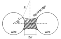
Файл:Capillary forces.png Schematic of the cross-section of two parallel, cilindrical wires of radius r, connected by a liquid bridge.(456 × 296 (41 Кб)) - 05:37, 7 мая 2021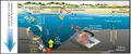
Файл:Ultimate sink.jpg Deep seafloor plastics as the source and sink of organic pollutants in the northern South China Sea(1274 × 531 (200 Кб)) - 09:44, 27 апреля 2021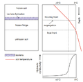
Файл:Freezing front.png ...ng front where water freezes to form segregated ice. Water moves upward to the frozen fringe within which hydraulic conductivity drops drastically as temp(782 × 773 (66 Кб)) - 00:47, 6 мая 2022Файл:Particle size distribution (PSD) of the sediments.png ...ffected by gravity erosion: a field study on steep loess slopes // Journal of Soils and Sediments. – 2020. – Т. 20. – № 3. https://doi.org/10.10(850 × 336 (279 Кб)) - 06:55, 14 апреля 2024Файл:Schematic diagram of the physically-based distributed sediment runoff model within grid-cell scale. .png Schematic diagram of the physically-based distributed sediment runoff model within grid-cell scale.(961 × 370 (352 Кб)) - 01:37, 30 апреля 2021
Файл:Intermittent Rivers.jpg Two contrasting hydrological phases of the Clauge River in temperate France during dry (top) and flowing phases (botto(800 × 450 (69 Кб)) - 04:55, 30 апреля 2021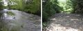
Файл:Ephemeral Stream.jpg Ephemeral stream in the Ozarks of southern Missouri (USA) under high water conditions; (b) same stream during(760 × 282 (105 Кб)) - 04:07, 30 апреля 2021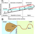
Файл:River plume.png ...cean with three zones of interest: normal flow, a transitional region, and the offshore river plume in (a) cross section and (b) plan view.(370 × 368 (93 Кб)) - 02:00, 26 апреля 2021
Файл:Table 4.1.2.png ...rley G.J., Fryirs K.A. Geomorphology and River Management: Applications of the River Styles Framework. Geomorphol. River Manag. Appl. River Styles Framew.(826 × 587 (135 Кб)) - 19:29, 25 апреля 2024


_of_the_sediments.png)