Bed topography: различия между версиями
Admin (обсуждение | вклад) |
Dymasus (обсуждение | вклад) (→Список литературы: - исправления С. на Р. в англоязычных статьях + изм. перевод использования ...) |
||
| Строка 1: | Строка 1: | ||
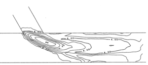
| − | [[Файл:Bed topograhy.png|альт=|мини|300x300пкс|Bed elevation contours show us bed topography<ref>Weerakoon S.B., Tamai N., Kawahara Y. Bed Topography, Bed Shear Stress Distribution and Velocity Field in a Confluence // Proceedings of Hydraulic Engineering. – 1990. – Т. 34. – № October 2017. – | + | [[Файл:Bed topograhy.png|альт=|мини|300x300пкс|Bed elevation contours show us bed topography<ref>Weerakoon S.B., Tamai N., Kawahara Y. Bed Topography, Bed Shear Stress Distribution and Velocity Field in a Confluence // Proceedings of Hydraulic Engineering. – 1990. – Т. 34. – № October 2017. – P. 307-312. <nowiki>https://doi.org/10.2208/prohe.34.307</nowiki>.</ref> (click to image to increase).<br /><br />]] |
==Рельеф речного русла== | ==Рельеф речного русла== | ||
| Строка 5: | Строка 5: | ||
==Определение на английском== | ==Определение на английском== | ||
| − | Bed topography represents the shape and features of the riverbed. The shape of a riverbed is largely determined by the relief of the terrain through which river crosses. <ref>Kumar V. Bed (Bottom) Topography // Encyclopedia of Snow, Ice and Glaciers / ред. Singh V.P., Singh P., Haritashya U.K. – Dordrecht: Springer Netherlands, 2011. – | + | Bed topography represents the shape and features of the riverbed. The shape of a riverbed is largely determined by the relief of the terrain through which river crosses. <ref>Kumar V. Bed (Bottom) Topography // Encyclopedia of Snow, Ice and Glaciers / ред. Singh V.P., Singh P., Haritashya U.K. – Dordrecht: Springer Netherlands, 2011. – P. 93. <nowiki>https://doi.org/10.1007/978-90-481-2642-2_38</nowiki>.</ref> |
==Пример использования термина на английском языке== | ==Пример использования термина на английском языке== | ||
| − | Uncertainty in the horizontal location of the aircraft, referred to as the “navigation error”, is an indirect source of error in the altitude of both the surface and '''''bed topography'''''. The error in altitude is the product of the error in horizontal position and the slope of the surface or bed, respectively.<ref>Hodge S.M., Wright D.L., Bradley J.A., Jacobel R.W., Skou N., Vaughn B. Determination of the surface and bed topography in Central Greenland // Journal of Glaciology. – 1990. – Т. 36. – № 122. – | + | Uncertainty in the horizontal location of the aircraft, referred to as the “navigation error”, is an indirect source of error in the altitude of both the surface and '''''bed topography'''''. The error in altitude is the product of the error in horizontal position and the slope of the surface or bed, respectively.<ref>Hodge S.M., Wright D.L., Bradley J.A., Jacobel R.W., Skou N., Vaughn B. Determination of the surface and bed topography in Central Greenland // Journal of Glaciology. – 1990. – Т. 36. – № 122. – P. 17-30. <nowiki>https://doi.org/10.1017/S0022143000005505</nowiki>.</ref> |
==Перевод использования на русском языке== | ==Перевод использования на русском языке== | ||
| − | Неточность | + | Неточность в горизонтальном положении воздушного судна, называемая также "навигационная ошибка" (точнее - тангаж), является косвенным источником погрешности отметок высот, как дневной поверхности, так и рельефа дна. Ошибка в значении высот складывается из ошибки планового положения и наклона дневной поверхности или уклона русла, соответственно. |
==Список литературы== | ==Список литературы== | ||
| − | <references /> | + | <references responsive="0" /> |
[[Категория:Русловые процессы]] | [[Категория:Русловые процессы]] | ||
Версия 09:09, 20 октября 2021
Рельеф речного русла
Это совокупность неровностей поверхности наиболее пониженной части речной долины, выработанной потоком воды.
Определение на английском
Bed topography represents the shape and features of the riverbed. The shape of a riverbed is largely determined by the relief of the terrain through which river crosses. [2]
Пример использования термина на английском языке
Uncertainty in the horizontal location of the aircraft, referred to as the “navigation error”, is an indirect source of error in the altitude of both the surface and bed topography. The error in altitude is the product of the error in horizontal position and the slope of the surface or bed, respectively.[3]
Перевод использования на русском языке
Неточность в горизонтальном положении воздушного судна, называемая также "навигационная ошибка" (точнее - тангаж), является косвенным источником погрешности отметок высот, как дневной поверхности, так и рельефа дна. Ошибка в значении высот складывается из ошибки планового положения и наклона дневной поверхности или уклона русла, соответственно.
Список литературы
- ↑ Weerakoon S.B., Tamai N., Kawahara Y. Bed Topography, Bed Shear Stress Distribution and Velocity Field in a Confluence // Proceedings of Hydraulic Engineering. – 1990. – Т. 34. – № October 2017. – P. 307-312. https://doi.org/10.2208/prohe.34.307.
- ↑ Kumar V. Bed (Bottom) Topography // Encyclopedia of Snow, Ice and Glaciers / ред. Singh V.P., Singh P., Haritashya U.K. – Dordrecht: Springer Netherlands, 2011. – P. 93. https://doi.org/10.1007/978-90-481-2642-2_38.
- ↑ Hodge S.M., Wright D.L., Bradley J.A., Jacobel R.W., Skou N., Vaughn B. Determination of the surface and bed topography in Central Greenland // Journal of Glaciology. – 1990. – Т. 36. – № 122. – P. 17-30. https://doi.org/10.1017/S0022143000005505.
